
An earthquake is a violent tremor in the Earth’s crust, creating a series of shock waves that travel in all directions from its place of origin. An earthquake, in simple words, is the shaking of the earth. It is a natural event that is caused by the release of energy, which generates seismic waves that travel in all directions.
Different causes of Earthquakes
Plate Tectonics
- Description – According to this theory, the Lithosphere (Earth’s outermost layer) is broken into some major and minor pieces, also known as tectonic plates. These plates, as believed, are moving constantly, though very slowly, over the semi-fluid asthenosphere. This movement is caused by the heat convection cell or convective flow within the Earth’s mantle, which lies below the rigid plates.
- How it causes earthquakes – When gigantic tectonic plates move, they interact at their respective boundaries. The interaction of these plates, whether the plates are pulling away from each other, one plate is submerged under another, or the plates slide past one another (horizontally), causes enormous pressure within the rocks. When this accumulated pressure surpasses the rock’s strength, the rock breaks and slips, releasing energy in the form of an earthquake. The majority of the earthquakes are caused by plate tectonics.
Fault Lines
- Description – A fault line is a sharp break or zone of breaks (fractures) in the Earth’s crust where two tectonic plates are significantly moving. Fault lines are essentially cracks in the Earth’s outer layer.
- How it causes earthquakes – Faults are the ground surfaces where the sudden slip and release of energy takes place during an earthquake. As the plates move (push or pull), pressure builds up. The rocks on both sides of the fault get locked together by friction. Eventually, the pressure overrides the friction, the rocks snap free and slip along each other along the fault. This sudden movement releases energy, causing the ground to shake. Earthquakes happen on fault lines.
Subduction Zones
- Description – A Subduction zone is an area where one plate is submerged under another plate into the Earth’s mantle. The location where the sinking of the plate took place is known as a subduction zone. A subduction zone is a specific type of convergent boundary. Deep oceanic trenches are found in these zones.
- How it causes earthquakes – When the subducting plate grinds over the overriding plate, it builds up immense friction and pressure. When this trapped or locked zone ultimately ruptures, it releases an enormous amount of energy. Subduction zones are responsible for the Earth’s most powerful and destructive earthquakes, also known as megathrust earthquakes.
Types of Earthquake Waves
If you turn on a light bulb in a dark room, a series of light waves is produced across the room. These waves spread out in all directions from the point where the light bulb is located. Similarly, any sudden disturbance in the Earth’s crust also creates vibrations in the crust, which travel in all directions from the point of origin. The location below the Earth’s surface where the earthquake starts or where the energy is released is called the focus or hypocenter. The point directly above it or nearest to the focus on the surface is called the epicenter (at 90°). There are two types of earthquake waves: Body waves and Surface waves.
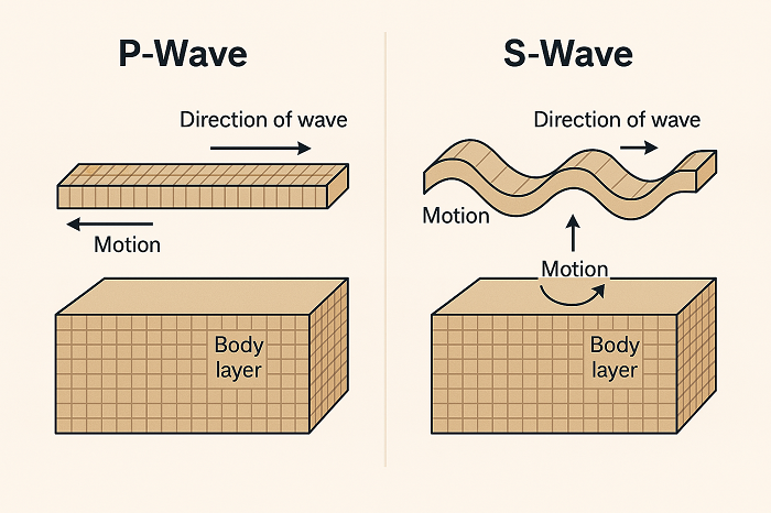
Body waves
Body waves are a type of seismic wave that are created as a result of energy release at the focus. These waves move in all directions and travel through the Earth’s interior. Hence, the name Body waves. Body waves are faster and arrive first at seismic stations. There are mainly two types of body waves:
P-waves (primary waves/ Compressional waves):
P-waves are the fastest seismic waves. They can travel through solid, liquid, and gaseous materials. These waves are the first to arrive at the surface, hence the first to be detected by seismographs.
S-waves (Secondary waves/Shear waves):
S-waves are slower than P-waves. They can travel only through solid materials. These waves arrive at the surface with some time lag. They are the second wave to arrive at a seismograph.
Surface waves
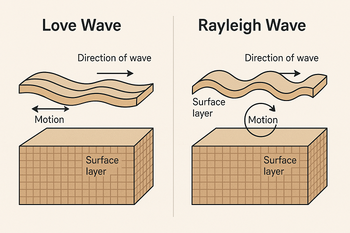
Surface waves are a type of seismic wave that travel along the Earth’s surface. When body waves interact with rocks, they generate new waves, and these waves are called surface waves as they move along the surface. Surface waves are the last to report on the seismograph, hence causing significant ground shaking and damage during an earthquake. These are more destructive waves. There are mainly two types of Surface Waves:
Love Waves:
Love waves are the fastest of the surface waves. When S-waves interact with the Earth’s surface and shallow structure, Love waves are formed.
Rayleigh Waves:
When the P-waves and S-waves interact with each other at the Earth’s surface, Rayleigh waves are formed. These waves are slower than love waves but cause the most intense shaking and damage.
Describe the different types of seismic waves and their characteristics. How do these waves help in understanding the Earth’s interior? (MPPSC 2023-24)
Explain the types of seismic waves and how they are used to determine earthquake epicenters. (RPSC 2022-23)
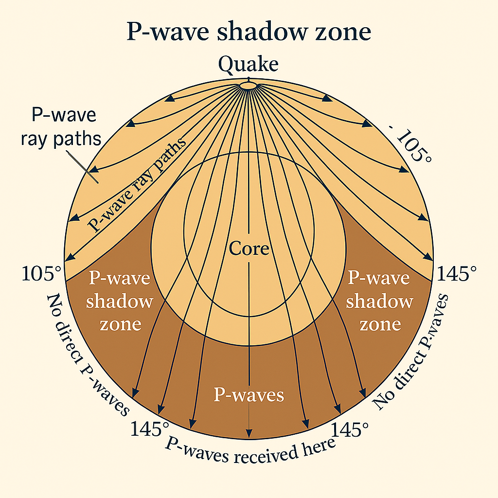
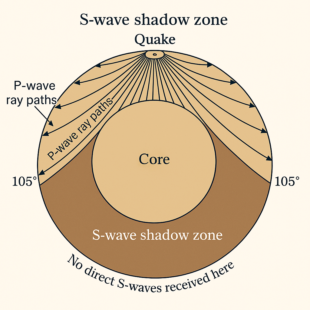
Shadow Zone
In the earlier section, we have seen how different waves are generated and how they travel and get recorded in seismographs. However, there are some specific areas where these waves are not reported. Such an area or zone is called the Shadow Zone. On Earth’s surface, a shadow zone is an area where direct seismic waves from an earthquake go undetected by seismographs.
Areas of Vulnerability and Seismic Zones of India
Depending on the degree of seismicity, India can be divided into the following regions:
- Kashmir and western Himalayas – J&K, Himachal Pradesh, and the sub-mountainous region of Punjab.
- Central Himalayas – Uttarakhand, UP, and sub-mountainous parts of Punjab.
- Northeast India – The Entire northeastern states, which are to the east of northern West Bengal.
- Indo-Gangetic Basin – Rajasthan, Plains of Punjab, Haryana, UP, and WB.
- Rann of Kachchh.
- Peninsular India, which includes the Island of Lakshadweep.
- The Andaman and Nicobar Islands.
Depending on the frequency and intensity of earthquakes, India can also be divided into the following regions:
- Himalayan Zone – This area falls under the most earthquake-prone area because of the ongoing collision of the Indian Plate with the Eurasian Plate. Earthquakes in this zone are primarily due to plate tectonics. This zone is also known as the zone of maximum intensity.
- Indo-Gangetic Zone – This zone is also known as the zone of comparative intensity because of the occurrence of moderate intensity earthquakes. This basin is a depression formed due to the immense weight of the rising Himalayas, and therefore, earthquakes in this zone are the result of the Himalayan collision.
- Peninsular Zone – The Peninsular India is often considered the stable region and has experienced only a few earthquakes. Therefore, this zone is also called the zone of minimum intensity. But there were some incidents of severe earthquakes also, like the 1967 Koyna earthquake, the 1993 Latur earthquake, and the 1997 Jabalpur earthquake.
Discuss the role of plate tectonics in causing earthquakes in the Himalayan region and the Indian Peninsular shield. What steps are being taken for earthquake disaster risk reduction in these zones? (UPSC 2023-24)
Explain the seismic zonation of India. Analyze the challenges in implementing earthquake-resistant building codes and retrofitting measures, especially in urban areas. (UPSC 2023-24)
Describe earthquake belts in India. (UPPSC 2022)
Analyze the causes of intra-plate earthquakes in the Peninsular India. What are the key strategies for mitigating earthquake risks in regions not typically considered seismically active? (RPSC 2023-24)
Comprehensive Impact of Earthquakes
Socio-economic Impact:
- Loss of Life and Property – One of the most immediate and tragic impacts is the loss of life and property, with many killed or severely injured.
- Displacement and Homelessness – Collapsing of buildings and properties forces many to take shelter in safe places and camps, causing mass evacuations and significant social disruption.
- Disruption of Livelihoods – Damaged infrastructure, halted supply chain often leads to widespread unemployment and economic instability.
- Poverty Escalation – Most affected are the vulnerable population, who often have limited resources like food, housing, and employment are further pushed into poverty.
- Public Funding and Fiscal Strain – Hazards like earthquake often pushes governments to fund rescue, relief, rehabilitation, and reconstruction, leading to significant fiscal pressure and increased debt.
Environmental Impact:
- Ground Shaking and Surface Faulting – The primary direct effect is the creation of cracks/ruptures and vibration on the Earth’s surface, causing displacement of land, serious damage to natural environments and infrastructure on the fault zone.
- Liquefaction – Soil liquefaction is a phenomenon where loose, low-density, saturated soil, because of the ground shaking, temporarily loses its strength and starts behaving like a liquid with no strength to uphold structures. This can cause structures to sink or tilt, or can cause severe damage.
- Landslides and Tsunamis – Earthquakes are more often followed by landslides in hilly areas due to vibrations caused by the earthquake, which can damage public infrastructure like roads and can alter landscapes. Underwater earthquakes can generate tsunamis that submerge coastal areas.
- Changes in Water Bodies – An Earthquake can alter groundwater levels. Vibrations can dry up water sources like springs, or new ones can also be formed. It can even change the course of rivers.
- Disruption of Ecosystems – Landslides and tsunamis can severely destroy natural habitats and ecosystems, which directly impact biodiversity.
Infrastructural Impact:
- An earthquake is perhaps most evident in the widespread destruction of the infrastructural environment, including –
- Residential, Commercial, and Public buildings.
- Transportation Networks like Roads, Bridges, Tunnels, and Railways.
- Utilities and Communication Systems like Water pipelines, Electricity lines and stations, Gas pipelines, Communication lines like telephone and cellular towers.
- Critical Facilities like Hospitals, Police Stations, Fire Stations, and Other emergency response facilities.
- Dams and Levees.
- Industrial Infrastructure.
India’s Multi-faceted Disaster Management Approach
Early Warning Systems (EWS):
Like Japan’s nationwide real-time early warning system, India’s system is still under development, but significant progress has been made –
- National Center for Seismology (NCS) – NCS is the centre point in maintaining the National Seismological Network and provides real-time earthquake information. NCS is the nodal agency for monitoring earthquake activities in the country under the Ministry of Earth Sciences.
- “BHOOKAMP” Mobile App – This app has been built to provide real-time parameters like location, time, and magnitude to users after an earthquake. It has been developed by NCS.
- Research in the Himalayan Region – India has been putting its effort and research into developing an EWS specifically for the Himalayan region, which is a highly seismic zone.
Building Codes and Standards:
The Bureau of Indian Standards (BIS) plays a crucial role in developing and updating standard codes that provide criteria for earthquake-resistant design and construction techniques for new structures. It also provides Retrofitting Guidelines for the repair and seismic strengthening of existing buildings.
Community Preparedness:
Community preparedness is recognized as one of the most vital components in the case of disaster, as local communities are the first responders. Initiatives include –
- Community-Based Disaster Preparedness – Mobilization of local communities for assessment of risks, developing local disaster plans, and training of volunteers.
- Awareness and Education – Spreading information on Do’s and Don’ts, safe construction practices for rural buildings (mud houses), and family disaster planning.
- Local Mapping and Safe Assembly Points – Encouraging local communities to participate in mapping and identify vulnerabilities. Also, designating a safe open space for evacuation and assembly after an earthquake.
National Disaster Management Authority (NDMA):
- Established under the Disaster Management Act 2005, NDMA is headed by the Prime Minister of India and is the responsible apex body for policy framing, plans, and guidelines for disaster management.
- NDMA plays a key role in:- policy & guidelines framing, approving the national plan, coordinating among various ministries and states, capacity building, research & development.
- As per the act, every state has an SDMA, which is headed by the respective Chief Minister and is responsible for implementing disaster plans at the state level.
Other key initiatives:
- National Institute of Disaster Management (NIDM) – Established under the Disaster Management Act 2005, NIDM has been assigned nodal responsibilities for human resource development, training, research, and policy promotion in the disaster management field under the Ministry of Home Affairs.
- Increasing Seismic Observations – India has, in the recent past, significantly expanded its National Seismological Network, enhancing real-time monitoring of earthquake activity.
- Earthquake Risk Indexing (EDRI) Project – NDMA’s EDRI project aims at assessing earthquake risks in different Indian cities. Phase 1 covered 50 cities, and Phase 2 targets 16.
Evaluate the effectiveness of India’s Tsunami Early Warning System since its establishment. What further advancements are needed to enhance its reach and accuracy for coastal communities? (UPSC 2023-24)


Leave a Reply